Sedimentary rocks are formed by the erosion of pre-existing rocks followed by a sequence of processes involving the transport of eroded materials from the source and depositing them layer by layer in a new destination. This step is also known as sedimentation. Pressure increases on the lower layers with the sedimentation on top of them. The lowest layer is pressurized the most, and water is squeezed out of it. Crystals of salts and minerals are formed on account of the increased concentration of cement and sediment particles. Depending upon the nature of the sediment, a sedimentary rock formation is called sandstone rock when made of small particles of minerals, quartz, and feldspar, a shale rock when formed from clay, a gypsum rock when made from sulfated minerals, and a conglomerate rock when formed by large particles of sand and pebbles. Sedimentary rocks constitute approximately eight percent of the Earth’s crust or one percent of the total earth by volume, but they cover an extensive area of the surface of the Earth.
1. Mount Everest
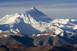
Mount Everest, at an elevation of 29,035 feet, or 8,850 meters, is the highest peak in the world. It is situated in the Himalayan range which is 1,400 miles long and 140-200 miles wide. It crosses five countries including: India, Nepal, Pakistan, Bhutan, and the People’s Republic of China. Mount Everest is a sedimentary formation composed of limestone, marble, shale, and pelite. The highest rock is formed of limestone, recrystallized dolomite, and siltstone. Many marine fossils have been found in the upper layers of Mount Everest. Geologists are of the opinion that Mount Everest evolved about 400 million years ago from the solidified limestone sediments deposited at the bottom of the then existing Tethys Sea.
2. Great Smoky Mountains
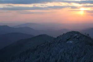
The Great Smoky Mountains, also known as the Smokies, are so named because of the blue mist that is always there. The Smokies are a mountain range situated at the border of Tennessee and North Carolina in the USA. Most of the rocks in the Great Smoky Mountains are sedimentary formations composed of clay, silt, sand, gravel, and calcium carbonate. The Smokies are best known for the Great Smoky Mountains National Park. The Smokies are listed as an International Biosphere Reserve and attract nine million visitors annually. President Franklin D. Roosevelt said about Smokies, ‘There are trees here that stood before our forefathers ever came to this continent; there are brooks that still run as clear as on the day the first pioneer cupped his hand and drank from them. In this Park, we shall conserve these trees, the Pine, the Red-bud, the Dogwood, the Azalea, the Rhododendron, the Trout and the Thrush for the happiness of the American people.’
3. Grand Canyon
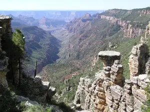
The Grand Canyon is a steep canyon created by erosion caused by the Colorado River in Arizona, USA. It is under the combined control of the Grand Canyon National Park, the Hualapai Tribal Nation, and the Havasupai Tribe. The Grand Canyon is 446 km long, 29 km wide, and 1,800 meters deep. Erosion by the Colorado River has exposed 2 billion years of geological history, and this why the Grand Canyon is a geologist’s paradise, and each layer reveals the story of thousands of years of erosion and sedimentation. Recent research concluded that the Colorado River started the sedimentary rock formation about 17 million years ago. Native Americans inhabited the Grand Canyon for thousands of years while the first European, Garcia Lopez de Cárdenasto, visited it in 1540. The Grand Canyon National Park is home to more than 34 mammals and 1,737 species of vascular plants.
4. The Wave Rock
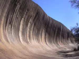
The Wave Rock is a sedimentary sandstone rock formation. It is located at the border of Arizona and Utah in the Paria Canyon Vermillion Cliffs Wilderness on the Colorado plateau. The Wave is comprised of U-shaped, wavy troughs of rocks. One of the two major troughs is 36 meters long and 19 meters wide while the other is 16 meters long and 2 meters wide. The erosion was initially caused by water, but now it is carried on by wind only. The waves are caused by the cyclic flow of sediment and wind ripples as is commonly observed on sand dunes. The scenic wave has a stunning beauty, and Hugo Martin of the Los Angeles Times commented that, ‘You can’t call yourself a landscape photographer if you haven’t snapped a photo or two of the Wave.’
5. The Ayers Rock

The Ayers Rock, also known as Uluru, is located in central Australia at a distance of 450 km from Alice Springs. It is a large, sandstone, sedimentary rock formation and is considered one of the most prominent landmarks of Australia. The Ayers Rock is 348 meters high with a circumference of 9.5 km. Most of it is underground, and only part of it is visible above the ground. It is of great cultural importance for the aboriginal tribes of Anangu. The rock is also noted for its unique feature of changing colors at different times of the day. Its color glows red at sunrise and sunset while it keeps on changing into pink, orange, and rust from dawn to dusk. It is composed of large pebbles, feldspar, quartz, and rock fragments.Uluru has been listed as a world heritage.
6. The Metéora

The name, ‘Meteora,’ is derived from ‘meteorite,’ which is a solid object from outer space. The Meteora is a sedimentary rock formation, composed of sandstone and pebbles. The sedimentary rock was formed 60 million years ago when Earth’s movements pushed the seabed upwards. It is located at 350 km from Athens, Greece. Meteora is best known for its monasteries built on top of the rock. At the base of the towering rock is situated the city of Kalambaka having a population of 12,000 inhabitants. Historians opine that the hermits inhabited this rock in the 11th century, but the monasteries were built in the 15th century. Only 6 of the total 24 monasteries built from time to time on top of the rock survive today.
7. Wilpena Pound
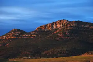
Wilpena Pound is a sedimentary rock formed about 500 million years ago. It is composed of quartzite and sandstone. The rock is located in the center of the Flinders Range at a distance of 429 km to the north of Adelaide, Australia. Blinman and Hawker are the closest towns. The highest peak in Pound, that is the highest peak in the Flinders Range, also is known as St. Mary’s Peak. The Wilpena sedimentary rock formation is best known for containing fossils of soft-bodied, multicellular animals which are not found anywhere else in the world.
8. Bryce Canyon National Park
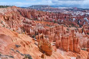
Bryce Canyon National Park, situated in southwestern Utah, U.S. is best known for its sedimentary rock formations which appear like huge, natural amphitheaters and are known as Hoodoos. Also known as an earth pyramid, a hoodoo is usually a tall and thin column protruding from the bottom of an arid basin. Its height may vary from 1.5 to 45 meters. The hoodoos are typically soft but topped by a harder, protective stone which prevents further erosion. Hoodoos’ sedimentary rock formations result from the frost weathering of the sedimentary bed of the lake. Bryce sedimentary rocks are of white, orange, and red colors which add to their attraction. This site was named after Ebenezer Bryce who got the ownership of land at a nominal cost.
9. Pamukkale
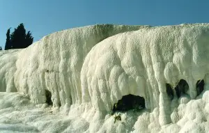
‘Pamukkale,’ meaning ‘Cotton Castle’ in Turkish, was named after the 2,700-meter, 600-meter wide and 150-meter high sedimentary rock formation on top of which the Greco Roman city of Hierapolis was built. Pamukkale rocks are composed of travertine, the sedimentary rock deposited from the hot springs. There are 17 hot springs with their water temperatures ranging from 35 to 100 degrees centigrade. The site is declared as a world heritage. The hot water springs had been used for bathing since thousands of years ago. The remains of ancient roman baths are still there, and the hot springs attract a large number of tourists every year.
10. Three Rondavels
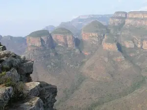
Three Rondavels, also known as the Three Sisters, is the name given to the sedimentary rock formation located in Mpumalanga Province in the Blyde River Canyon, South Africa. They are three, beautiful rock formations resembling typical African round huts known as Rondavels. These sedimentary rock formations are mainly composed of quartzite and shale. Three Rondavels attract large numbers of tourists every year.
Conclusion:
The sedimentary rocks cover more of the Earth’s surface than other rocks which are known as igneous and metamorphic rocks. The thickness of the sedimentary rocks being 1.8 km at an average is less than the other rock formations. The importance of the sedimentary rocks is more exciting because they store all the natural gas, oil, groundwater, salt deposits, phosphates, and other natural resources. In fact, the sedimentary rocks serve as the largest data bank of the world’s geography.
http://commons.wikimedia.org/wiki/File:Three_Rondavels_Blyde_River_Canyon.jpg


Leave a Reply