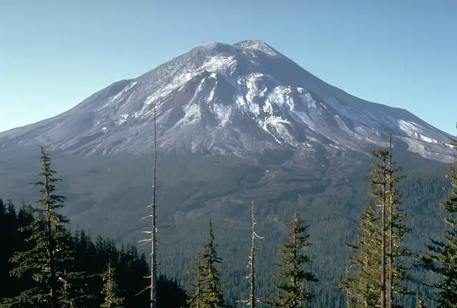
 Mount St. Helens was a conical shaped, youthful volcano until its eruption in 1980. It is rightfully referred to as the Mount Fuji of America. It is located in Skamania County of Washington. Its position is 46.2 degree North Latitude and 122.18 degree West Longitude. Height of this mountain is 2,549 meters (8,363 feet). Mt St. Helens comes under the volcanic type of stratovolcano. The composition of this mountain is Basalt to Rhyodacite. Some of the towns nearing this mountain are Castle Rock, WA; Olympia, WA; Vancouver, WA; Yakima, WA; Portland, OR. Let us see some of the astonishing facts regarding this volcanic mountain given below:
Fact 1: An English explorer George Vancouver who made a survey of the area in the late 18th century gave the name Mount St. Helens to this mountain based on the name of one of his close friends, British diplomat Lord St Helens.
Fact 2: A huge debris avalanche, which occurred during the 1980 eruption, removed the upper 400 meters (1300 feet) of the summit. This impact left behind a horse-shoe shaped crater, which is 2 x 3.5 km (1.2 x 2.2 mi) in dimension. This is filled at the top by a lava dome and a glacier. The volcano has a complex magmatic system and it is an explosive dacite volcano.
Fact 3: The four eruptive stages, which began around 275,000 years ago, led to the formation of Mount St. Helens and since then it has been the most active volcano during the Holocene in the Cascade Range. Older St. Helens edifice was formed 12,800 years ago, when tephra, lava domes, and pyroclastic flows were erupted. Only few lava flows extended beyond the base of the volcano. Around 3,000 years ago, major part of the modern edifice was formed due to volcanic eruptions of wide variety of products thrown from the summit and flank vents. The Goat Rocks area on the north flank,witnessed the historical eruptions of the 19th century, which were seen by early settlers.
Fact 4: Massive avalanche of debris caused during the eruption of St. Helens in 1980 slid from top of the mountain and hit the base of the spirit lake with such a force that, a 250 meter high wave smashed through the lake to the other shore. The height of this wave is over 6 times the devastating tsunami caused by the Krakatoa eruption in 1883! But by gods grace, there was no living population near the vicinity of the lake.
Fact 5: The three river systems namely: the Toutle River on the north and northwest, the Kalama River on the west, and the Lewis River on the south and east, are fed by the streams originating from Mt St Helens. Abundant rain and snow continuously feed the streams. The mountain gets an average rainfall of 140 inches (3,600mm) and the mountain’s upper slopes have snow packs of depth 16 feet.
Fact 6: During the volcanic eruption of 1980, nearly 200 miles of dense forest got buried under millions of tons of avalanche debris, lava, ash and mud. Charlie Crisafulli, a lone ecologist spent months in the blast zone and was mesmerized by the quick colonization of the waste land by flora and fauna.
Fact 7: Mt St. Helens has erupted more frequently than any other volcano, during past 4,000 years in the cascade region.
Fact 8: Dense ash cloud formed during the Mt St. Helens’ eruption in 1980, turned daylight into darkness in eastern Washington, causing streetlights to turn on in Yakima and Ritzville.
Fact 9: Volcanic mud flow called lahars, comprising of sand, mud and rocks damaged 27 bridges and 200 homes and forced 31 ships to remain in ports.
Fact 10: Mt St. Helens erupted in 2004 again and continued its eruptions till 2008. At present the volcano is silent but active.


Leave a Reply